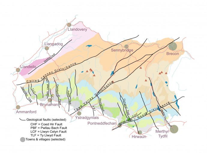
A quick tour around some of the most important geological structures of Fforest Fawr.
Faults within the Geopark can be broadly grouped into two sets – those which form a part of the swarm of north-northwest to south-southeast trending faults (labelled *N/S) and those aligned with the major northeast to southwest trending ‘disturbances’ (labelled *E/W).
The NNW-SSE faults are virtually all ‘normal’ faults which downthrow rocks to the west (or strictly to the WSW) – that is to say that the movement along the fault is such that the rocks on their western sides have moved down relative to those on the east. The amount of movement varies from fault to fault and indeed along individual faults.
The NE-SW aligned faults are associated with the Caledonian Orogeny and hence are referred to as ‘Caledonoid’ structures. The origins of some no doubt preceded that mountain-building period and many will have been active since that time. Three of the larger faults are closely associated with folds such as the one splendidly revealed at Cribarth in the upper Swansea Valley. These composite structures are known as ‘disturbances’ in South Wales. The sense of movement on these faults has varied over time.
The majority of minor faults have never been given a name – those faults that have are listed below:
Carreg Cennen Disturbance (*E/W)
A zone of faults and folds extending for dozens of kilometres across country and taking its name from the spot where it most dramatically affects the landscape – Carreg Cennen Castle being perched atop a mass of Carboniferous Limestone trapped between two faults forming a part of the disturbance. This disturbance forms a part of the Welsh Borderland Fault Zone which is a ‘Caledonoid’ structure.
Clun-gwyn Fault (*NW/SE)
Labelled CF (= ‘Clyngwyn Fault’) on BGS maps, this fault is seen to form the face over which the Afon Mellte falls at Sgwd Clun-gwyn. It is also the fault originally responsible for the falls at Sgwd yr Eira.
Coed Hir Fault (*E/W)
Runs for 3km parallel to the Neath Disturbance just north of Penderyn, downthrowing Millstone Grit rocks to the south.
Cribarth Disturbance (*E/W)
A zone of faults and folds extending for dozens of kilometres across country and becoming the Tawe Valley Disturbance to the southwest of the miniature mountain from which it derives its name. It forms an arm of the Welsh Borderland Fault System and is regarded as a ‘Caledonoid’ structure.
Cwm Llwyd Fault (*N/S)
Runs N-S for over 4km from near Brest Cwm Llwyd to west of Brynaman downthrowing Coal Measures, Millstone Grit and Carboniferous Limestone to the west.
CwmllynFell Fault (*N/S)
Runs N-S from Brest Rhiw on the north side of the Black Mountain, passing just west of Cwmllynfell, continuing in all for 13km to Cilmaen in the Swansea Valley where it encounters the Swansea Valley Disturbance. It downthrows Coal Measures rocks to the west though it also affects rocks down to the ORS Brownstones Formation.
Dinas Fault (*E/W)
Forms a part of the Neath Disturbance in the vicinity of Dinas Rock and Bwa Maen at Pontneddfechan.
Gardeners Fault (*N/S)
A major fault of the western coalfield which just extends into the Geopark at its northern end at Llandyfan. It terminates against the Carreg Cennen Disturbance. In common with similarly aligned faults in the area it downthrows rocks to the west along its 17km length. Its southern end is at the Swansea Valley Disturbance.
Henrhyd Fault (*N/S)
Important insofar as it gives rise to the spectacular Henrhyd Falls near Coelbren, this fault extends SSW from the Cribarth Disurbance north of Craig-y-nos to the coalfiled at Banwen just south of the Geopark. Its downthrow is to the west.
Llwyncelyn Fault (*N/S)
Runs N-S for 6km through Brynaman downthrowing Coal Measures rocks to the west.
Merthyr Church Fault (*N/S)
Extends NW-SE through Merthyr Tydfil area and enters the Geopark at Cefn Coed-y-cymmer. It and associated faults help define the alignment of the upper Cwm Taf between Merthyr Tydfil and Storey Arms. Downthrows to the west.
Neath Disturbance (*E/W)
A zone of faults and folds extending for dozens of kilometres across country northeast-wards from Swansea Bay up the Vale of Neath. It is sometimes referred to as the Vale of Neath Disturbance. It continues past Dinas Rock and Bwa Maen, through Moel Penderyn, under Pontsticill Reservoir and on via Blaen Onneu and the valley north of Sugar Loaf towards Hereford. It is a ‘Caledonoid’ structure.
Palleg Fault (*N/S)
Runs N-S from SE of Foel Fraith for 8km to Lower Cwm Twrch and continuing as the Allt y Grug Fault to Ystalyfera. It downthrows the Coal Measures rocks to the west but extends into the Millstone Grit and Carboniferous Limestone too.
Pwllau Bach Fault (*N/S)
Runs SSE from the Cribarth Disturbance through Abercraf and out of the Geopark through the Coal Measures past Seven Sisters. Its downthrow is to the west.
Sawdde Fault (*E/W)
A ‘Caledonoid’ structure running NE-SW between Llangadog and the Sawdde Gorge and linking with other similarly aligned faults forming a part of the Welsh Borderland Fault Zone.
Swansea Valley Disturbance (*E/W)
– see Tawe Valley Disturbance
Tawe Valley Disturbance (*E/W)
A zone of faults and folds extending for dozens of kilometres across country NE-wards from Swansea Bay up the valley of the Tawe. It is sometimes referred to as the Swansea Valley Disturbance. It continues beyond Cribarth as the Cribarth Disturbance as far as Brecon and beyond. It is a ‘Caledonoid’ structure.
Ty Llwyd Fault (*N/S)
Runs SSE from the Carreg Cennen Disturbance at Carreg Cennen, splitting around Cwmberach and continuing to Banc Cwmhelen, south of Garnant. It downthrows rocks of Lower Devonian to upper Carboniferous age down to the west.
Welsh Borderland Fault System (*E/W)
A zone extending from Pembrokeshire to the western edge of the Peak District within which a series of major faults occur and which defines the south-eastern edge of the former Welsh Basin. It includes the Carreg Cennen Disturbance, the Sawdde Fault and the Myddfai Steep Belt. The Cribarth Disturbance is an offshoot of the WBFS. All are ‘Caledonoid’ structures.


